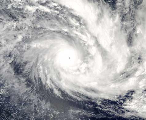
Extremely Severe Cyclonic Storm “FANI” to cross Odisha Coast on May 3

Yesterday’s extremely severe cyclonic storm over westcentral Bay of Bengal (BoB) moved north-northeastwards and lay centered at 1430 hrs IST of 02nd May, 2019 over the same region near latitude 17.1°N and longitude 84.8°E, about 320 km south-southwest of Puri (Odisha), 170 km east-southeast of Vishakhapatnam (Andhra Pradesh) and 610 km south- southwest of Digha (West Bengal).
It is very likely to move north-northeastwards and cross Odisha Coast between Gopalpur and Chandbali around Puri during forenoon of 3rd May, with maximum sustained wind speed of 170-180 kmph gusting to 200 kmph. Landfall process is very likely to continue till noon/afternoon of tomorrow the 3rd May.
After the landfall the system is very likely to continue to move north-northeastwards, weaken gradually and enter into West Bengal as a Severe Cyclonic Storm with the wind speed of 90-100 kmph gusting to 115 kmph. It is very likely to move further north- northeastwards and emerge into Bangladesh on 4th April evening as a Cyclonic Storm with wind speed 60-70 kmph gusting to 80 kmph.
The cyclone is being tracked by Doppler Weather Radars Vishakhapatnam & Machilipatnam.
Warnings:
- Heavy rainfall warning
- North Andhra Pradesh: Light to moderate rainfall at most places with isolated heavy to very heavy falls over Visakhapatnam and Vijayanagaram district and isolated heavy to extremely
heavy falls (>20 cm) over Srikakulam district on 2nd May and with heavy to very heavy rainfall at isolated places over Srikakulam district on 3rd May.
- Odisha: Light to moderate rainfall at most places with heavy to very heavy rainfall and extremely heavy falls (over Ganjam & Gajapati districts) at isolated places very likely over south coastal & adjoining interior Odisha on 2nd It is likely to increase with moderate rainfall at most places and heavy to very heavy rainfall at a few places and extremely heavy falls at isolated places over coastal Odisha & adjoining districts of interior Odisha on 3rd. Light to moderate rainfall at most places with heavy to very heavy falls at isolated places over Balasore, Mayurbhanj districts of north Odisha on 4th May.
- West Bengal: Light to moderate rainfall at most places with heavy to very heavy rainfall at a few places and extremely heavy falls at isolated places very likely over coastal & adjoining districts of West Bengal on 3rd; and heavy to very falls at isolated places over Gangetic West Bengal on 4th Light to moderate rainfall at most places with heavy falls at isolated places over Sub-Himalayan West Bengal & Sikkim on 4th May.
- Arunachal Pradesh and Assam & Meghalaya: Light to moderate rainfall at most places with isolated heavy to very heavy falls very likely over Arunachal Pradesh and Assam & Meghalaya on 4th & 5th May; with isolated extremely heavy falls over Assam & Meghalaya on 4th. Light to moderate rainfall at many places with isolated heavy falls very likely over Nagaland, Manipur, Mizoram & Tripura on 4th.
(ii) Wind warning
- Gale wind speed reaching 180-190 kmph gusting to 210 kmph is very likely to prevail over westcentral Bay of Bengal around system centre during next 24 hours and decrease thereafter.
- Squally wind speed reaching 40-50 kmph gusting to 60 kmph is very likely to prevail along & off north Andhra Pradesh & Odisha Coasts and become gale wind speed reaching 60-70 kmph gusting to 85 kmph from 2nd May night. It is very likely to become 170-180 kmph gusting to 200 kmph along & off south Odisha & adjoining north Andhra Pradesh (Srikakulam District) coasts; and 90-100 kmph gusting to 115 kmph along & off remaining districts of coastal Odisha and north Andhra Pradesh (Visakhapatnam and Vijayanagaram Districts) by 3rd May forenoon for subsequent 12 hours and decrease
- Squally wind speed reaching 40-50 kmph gusting to 60 kmph is very likely along & off West Bengal coast from 2nd May evening. It is very likely become gale wind speed reaching 60-70 kmph gusting to 85 kmph from 3rd May afternoon and become 90-100 kmph gusting to 115 kmph from 4th May early morning for subsequent 12 hours and decrease


