Cyclone ‘PHETHAI’ warning for Andhra Pradesh & Puducherry Coasts
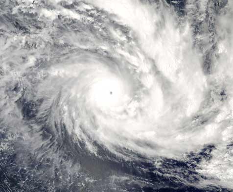
The Cyclonic storm ‘PHETHAI’ over southwest Bay of Bengal moved further north-northwestwards with a speed of 16kmph during past 06 hours and lay centred at 0830 hrs IST of 16th December, 2018 over southwest & adjoining West central Bay of Bengal near latitude 11.8°N and longitude 84.0°E, about 460 km northeast of Trincomalee (Sri Lanka), 430 km east-southeast of Chennai (Tamil Nadu),560 km south-southeast of Machilipatnam (Andhra Pradesh) and 600 km south-southeast Kakinada (Andhra Pradesh).It is very likely to intensify further into a Severe Cyclonic Storm during next 24 hours.It is very likely to move north-northwestwards and cross Andhra Pradesh coast between Machilipatnam and Kakinada during 17th December afternoon. However, due to unfavourable environmental conditions, it is likely to weaken slightly before landfall and cross coast as a cyclonic storm.
Forecast track and intensity are given in the following table:


| Date/Time(IST) | Position(Lat.°N/ long.°E) | Maximum sustained surface wind speed (Kmph) | Category of cyclonic disturbance |
| 16.12.18/0830 | 11.8/84.0 | 80-90 gusting to 100 | Cyclonic Storm |
| 16.12.18/1130 | 12.1/83.7 | 85-95 gusting to 105 | Cyclonic Storm |
| 16.12.18/1730 | 13.0/83.0 | 90-100 gusting to 110 | Severe Cyclonic Storm |
| 16.12.18/2330 | 13.9/82.6 | 90-100 gusting to 110 | Severe Cyclonic Storm |
| 17.12.18/0530 | 14.9/82.4 | 80-90 gusting to 100 | Cyclonic Storm |
| 17.12.18/1730 | 16.4/82.3 | 70-80 gusting to 90 | Cyclonic Storm |
| 18.12.18/0530 | 17.8/82.8 | 55-65 gusting to 75 | Deep Depression |
| 18.12.18/1730 | 18.6/83.5 | 40-50 gusting to 60 | Depression |
Warnings:
- Heavy rainfall warning
- Rainfall at most places with heavy to very heavy falls at a few places very likely over coastal Andhra Pradesh on 16th& 17th December. Extremely heavy falls (≥ 20 cm) at isolated places also likely over north coastal Andhra Pradesh on 17th December. Rainfall at many places with heavy falls at isolated places likely over adjoining districts of north Tamil Nadu on 16th December.
- Rainfall at many places with heavy falls at isolated places on 16th and rainfall at most places with isolated heavy to very heavy falls likely over Odisha on 17thand heavy falls at isolated places over south Chhattisgarh on 16th& 17th December. Rainfall at many places with heavy falls at isolated places also likely over Jharkhand on 17th December.
- Rainfall at most places with heavy falls at isolated places likely over Gangetic West Bengal on 17th December.
- Wind warning for Andhra Pradesh, north Tamil Nadu, Puducherry and south Odisha coasts
- Squally wind speed reaching 45-55 kmph gusting to 65 kmph prevails along & off South Andhra Pradesh, north Tamilnadu& Puducherry coasts. It is very likely to increase gradually becoming gale wind speed of 80-90 kmph gusting to 100 kmph along & off central Andhra Pradesh coast and Yanam district of Puducherry on 17th December.Gale wind speed reaching 60-70 kmph gusting to 80 kmph is likely to prevail along & off remaining parts of Andhra Pradesh coast and squally wind speed 40-50 kmph gusting to 60 kmph is likely to prevail along & off north Tamilnadu & Puducherry coasts on 17th December.
- Strong wind speed reaching 30-40 kmph gusting to 50kmph likely along & off South Odisha coast on 17th December.
- Wind warning for Sea areas
- Gale wind speed reaching 80-90kmph gusting to 100 kmph prevails over southwest & adjoining westcentral Bay of Bengal. It is very likely to become gale wind speed reaching 80-100 kmph gusting to 110 kmph over westcentral Bay of Bengal on 17th December.
- Strong wind speed reaching 30-40 kmph gusting to 50kmph likely over northwest Bay of Bengal on 17th December.
- Sea condition
The sea condition is high over southwest & adjoining westcentral Bay of Bengal around system center. The sea condition is very likely to be high to very high over westcentral & adjoining southwest Bay of Bengal from 16th evening to 17th December. It is rough to very rough along & off south Andhra Pradesh, north Tamil Nadu & Puducherry coasts and will become very rough to high along & off central Andhra Pradesh coast and Yanam district of Puducherry from 16th evening to 17th December evening.
- Storm Surge Warning
Storm surge of height of about 0.5 m to 1.0 m above the astronomical tides likely to inundate the low lying areas of Coastal Andhra Pradesh (East & west Godavari, Vishakhapatnam, Krishna and Guntur Districts) and Yanam district of Puducherry at the time of landfall.