Scientists claim to have photographed foothills of Thawites Glacier
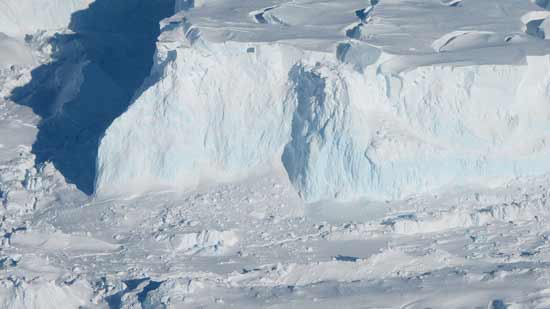
Scientists claim to have photographed the foothills of the Antarctic glacier ‘Thwaites’ for the first time. They took the help of a robotic submarine to take this picture. This step of scientists will help in better monitoring of ice sheet. This ‘infamous glacier’ is responsible for the rise in sea level.
According to researchers from the Georgia Institute of Technology in the US, the Thwaites Glacier causes sea water levels to rise around four percent globally. In such a situation it becomes a matter of concern that this will end the existence of the glacier and it increases the sea level of the water by 25 inches. This robotic submarine ‘Icefin’ visited the Thwaites, where the glacier lies above sea level and floats above the water. Scientists have found that this grounding line is important for the stability of the foothills of the Thwaites Glacier, because the farther it goes, the faster it can flow and the higher the sea level.


Grounding zone was investigated for the first time
Brittany Schmidt, researcher at the Georgia Institute of Technology and part of the project, says, “Checking the grounding line is important for such tasks, because we can measure it correctly.” ‘This is the first time anyone has done this or ever seen the grounding zone of major glaciers under water. This is where the massive glacier melting and destabilization can occur. ‘
Involved in five campaigns
Under this project, Icefin traveled around 15 km during five expeditions. During this time, two routes up to the grounding zone were found and in one, the icefin reached very close to the place where the sea surface meets the ice. Schmidt said, ‘We saw ice melting rapidly from the sedimentary and warm ocean waters.’
New concern after Greenland
According to researchers, the amount of ice flowing into the sea from Thwaites and its neighboring glaciers has nearly doubled in the last 30 years. Schmidt says, “Greenland’s contribution to sea level has already reached alarming levels and now the Antarctic is also ready to play a rapid role in it.” He explained, “It is the largest part of ice on Earth and The rise in sea level will play a greater role in the next 100 years. It is the largest source of uncertainty in the climate system. ‘
Data analysis
Researchers said that scientists from all over the world are busy analyzing the data of this unprecedented mission. These range from seismic and radar measurements to publishing studies on glaciers. British Antarctic Survey oceanographer Keith Nichols said, “We know that the warm sea water is eroding many glaciers in the Western Antarctic, but we are particularly concerned about the Thwaites.” This new data will help in understanding the process happening, so that we can make more accurate predictions about the future. ‘